Augusta, Maine
Augusta, Maine: Kennebec flooding and a documented route back indoors
Explore Augusta's Kennebec River flood context, official gauge resources and restoration decisions after water reaches downtown or other affected buildings.
Published · Reviewed · Water Damage Dispatch
Educational guidance, not a current warning, parcel-level hazard assessment, emergency service, insurance coverage decision or guarantee of contractor availability. Follow local authorities and call 911 for immediate danger.
Property loss in Augusta
Augusta's relevant river is the Kennebec, not the Savannah River beside the Georgia city with the same name. Federal water-science resources provide a concrete local record that can anchor a more accurate discussion of preparedness and restoration.
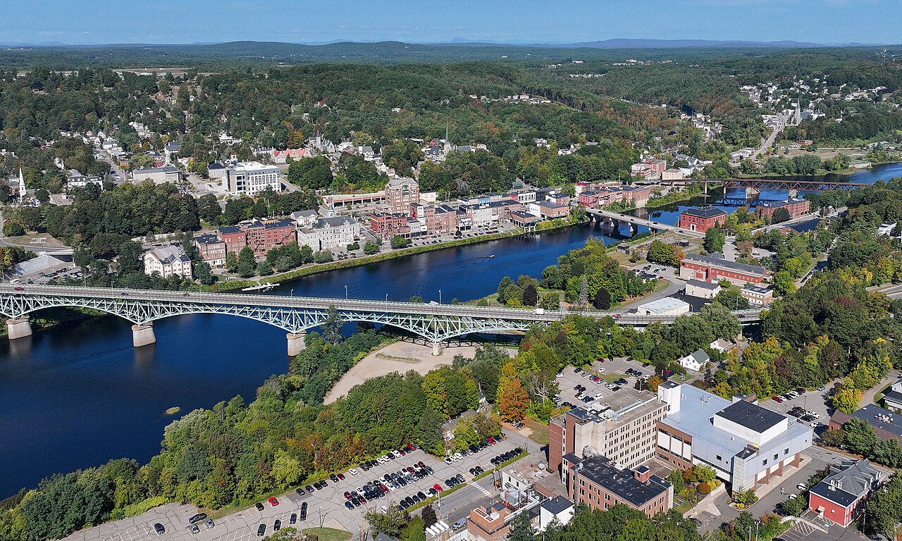
Downtown imagery documents an actual Kennebec loss setting
USGS publishes a comparison showing downtown Augusta during flooding after a December 2023 rainstorm and under normal flow in September 2024. That record demonstrates a real river-related impact without telling an owner what happened at a separate address. It is useful context for asking how water might reach a building and what official map or local floodplain information is needed.
Sources: Kennebec River in downtown Augusta, Maine during flooding and normal flow | U.S. Geological Survey
Gauge information is not an indoor condition report
The National Water Prediction Service provides a Kennebec River at Augusta gauge page with flood-impact information. Current readings and forecasts should be checked there rather than copied into an evergreen article. Even when water recedes, a gauge cannot determine whether wall cavities, contents or building equipment are safe. Those questions require observations at the property after authorized entry.
Sources: Kennebec River at Augusta - National Water Prediction Service · Guidelines for Cleaning Safely After a Disaster | Natural Disasters | CDC
Recovery should account for continued use of the space
For an Augusta residence or workplace affected by outside water, cleanup decisions extend beyond removing what is visible. A room may depend on other systems or contain materials that cannot be retained after contamination. Restoration providers help by documenting those distinctions and coordinating work stages, allowing owners to understand which spaces and contents can recover and which require additional repairs or specialist review.
Sources: Guidelines for Cleaning Safely After a Disaster | Natural Disasters | CDC · Resources for Flood Cleanup and Indoor Air Quality | US EPA
Use building evidence alongside river information
For an Augusta property affected by Kennebec water, ask the provider to explain the boundary of actual contact, not merely reproduce the river's outside level. Contamination, material construction and the condition of contents can change the work from one space to another.
After authorized access and appropriate service assessment, a useful record tracks cleaning, removal decisions and moisture in retained assemblies. It should also identify repairs outside the restoration contract. The gauge and historical photographs help explain the local setting, but cannot certify a room, choose a material outcome or establish the day a household or employer can resume normal use.
Sources: Guidelines for Cleaning Safely After a Disaster | Natural Disasters | CDC · Resources for Flood Cleanup and Indoor Air Quality | US EPA
If damage happens
Consult the Kennebec resource directly
Use the official Augusta gauge for current readings and forecasts rather than a historical photograph or this guide.
Wait for property-specific access
Follow closures and seek appropriate help if structure, services or outside conditions remain uncertain.
Ask for an indoor condition record
Require an explanation of contacted layers and contents, proposed treatment and the checks supporting further repairs.
Locate Augusta
City-center location map only—not a flood-risk map, hazard boundary, live warning or address-specific assessment.
Official sources and review notes
Local sources establish geographic and hazard context. CDC and EPA resources provide general recovery guidance. Historical notices and draft plans are identified in the text; they are not current warnings or funding approvals.
- Kennebec River in downtown Augusta, Maine during flooding and normal flow | U.S. Geological Survey — usgs.gov. Checked 2026-10-18.
- Kennebec River at Augusta - National Water Prediction Service — water.noaa.gov. Checked 2026-10-18.
- Guidelines for Cleaning Safely After a Disaster | Natural Disasters | CDC — Centers for Disease Control and Prevention. Checked 2026-10-18.
- Resources for Flood Cleanup and Indoor Air Quality | US EPA — U.S. Environmental Protection Agency. Checked 2026-10-18.
Augusta recovery questions
Does a falling Kennebec gauge show my Augusta walls are dry?
No. The gauge reports outside river conditions. Enclosed building materials need their own moisture assessment after access is safe.
Can the USGS downtown photograph establish damage at my address?
No. It documents a particular historical view. Your building's source, material contact and condition require separate observations and assessment.
Compare listings, then confirm the fit
Browse listed companies in Maine. A state listing is not proof of service at your address, an emergency dispatch promise or a coverage decision. Confirm location, services and availability directly.
Browse Maine restoration companies · Regional property-damage guide