Home recovery
Hurricane Isaias: Florida Panhandle Impacts & Recovery, October 2026
Explore Hurricane Isaias’s October 2026 Florida impacts in Destin, Pensacola, Fort Walton Beach and nearby towns, with sources and practical recovery steps.
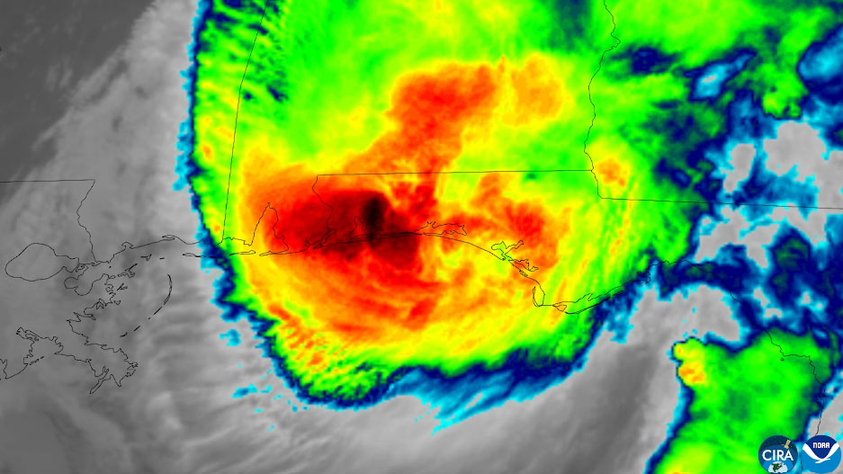
Hurricane Isaias made landfall near Destin on Florida’s Panhandle at approximately 8:30 p.m. Central Daylight Time on October 9, 2026. The National Hurricane Center’s landfall update reported maximum sustained winds of 105 mph and a minimum central pressure of 971 millibars. That made Isaias a Category 2 hurricane at landfall, even though it had been stronger over the Gulf earlier that day.
The consequences extended beyond the point where the center crossed the coast. Official observations and local reporting document damaging winds, storm-driven water, roof failures, fallen trees, power interruptions and recovery needs from the Pensacola area through the Emerald Coast. This article brings those records together with practical guidance for homeowners, renters, condominium associations and small businesses deciding what to do next.
The town coverage below is not a complete damage survey or a claim that every property was affected. A reported wind gust, a water-level measurement and an assistance distribution site each establish different things. We identify those differences, link the supporting sources, and provide directory searches without claiming that a contractor is available, dispatched, endorsed by emergency officials or already working in a particular neighborhood.
Key takeaways
- Landfall: near Destin, October 9, 2026, about 8:30 p.m. CDT; the NHC reported 105 mph maximum sustained winds.
- Documented impacts include the Destin–Fort Walton Beach area, Pensacola, Gulf Breeze, Navarre Beach, East Milton, the Walton County coast and Panama City Beach.
- The NHC’s 5.6-foot Panama City Beach observation was a gauge water level above mean higher high water—not the depth in every home or street.
- Put safety before cleanup, photograph damage when safe, notify the appropriate insurers, and compare written restoration scopes before authorizing work.
- Recovery resources were checked October 15. Use Florida Disaster and county emergency management for changing locations, hours, road restrictions and assistance eligibility.
When and where did Hurricane Isaias hit Florida?
The NHC’s October 9 landfall bulletin places the center near Destin at 8:30 p.m. CDT, or 01:30 UTC on October 10. Those dates describe the same event in different time zones. The bulletin reports 105 mph maximum sustained winds. Do not substitute an isolated higher gust for the storm’s sustained-wind rating, or describe its earlier Category 3 intensity as its landfall category.
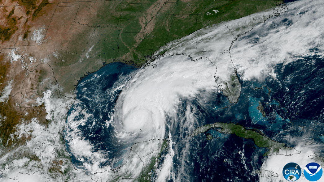
NOAA’s October 8 satellite report describes Isaias strengthening over the Gulf after becoming a hurricane late on October 7. Subsequent reporting describes a Category 3 peak before weakening to Category 2 at the coast. Recovery reporting on October 10–12 then documented roof damage, debris and service interruptions. This sequence matters when comparing forecasts issued before landfall with the observations recorded afterward.
- October 7–8: NOAA monitored the developing hurricane over the Gulf.
- October 9, 8:30 p.m. CDT: the NHC confirmed landfall near Destin.
- October 10 onward: agencies and communities assessed damage and organized recovery.
- October 15: this article’s research and resource review date; not a new landfall date.
Destin: landfall, flooding and wind-damaged property
Destin is the anchor location in the official landfall record. Reporting after the storm described flooded streets, fallen trees and power outages, with photographs and reporting of damaged waterfront structures and commercial roofing. These observations establish that some properties were affected, not that all neighborhoods or waterfront buildings experienced the same loss.
For a Destin property, begin with the building’s actual condition: missing roof covering, broken openings, water inside occupied rooms and damage around electrical equipment require different assessments. A photographed waterline should be recorded separately from a roof leak. Ask a restoration company whether its proposed work includes water extraction, contents handling, moisture mapping and drying records, and confirm any roof or structural repair responsibilities separately.
Fort Walton Beach and the Santa Rosa Sound observation
The NHC landfall update reported a WeatherFlow station near Santa Rosa Sound measuring a 116 mph gust and a 91 mph sustained wind. That is a station-specific observation, not a uniform reading for Fort Walton Beach or the entire sound. The October 10–11 recovery report also documented siding damage and a boat displaced onto land in Fort Walton Beach.
Florida’s disaster information page listed a multi-agency resource center at the Destin–Fort Walton Beach Convention Center when reviewed for this article. Resource centers can connect residents with participating agencies, but their existence does not establish insurance coverage or a grant entitlement. Check the state’s current listing before traveling. For wet interiors, have safety and moisture conditions assessed before turning on affected equipment.
Pensacola and Escambia County: roof damage, trees and outages
The NHC recorded a WeatherSTEM station near Pensacola reporting a 100 mph gust and a 63 mph sustained wind around landfall. News reporting described roof damage at the Rest and Relax Inn, debris, fallen trees and power loss in the Pensacola area. These are documented examples rather than an address-by-address assessment of the city or Escambia County.
After a roof opening, moisture can affect insulation and ceiling assemblies even where the floor appears dry. Photograph visible damage from a safe position and ask what areas were inspected beyond the obvious leak. Stay away from fallen wires and damaged trees. The state’s Isaias page listed Pensacola assistance and feeding locations; verify today’s status rather than relying on an old screenshot or an informal social post.
Milton and East Milton: inland wind damage and blocked access
The inland communities were not outside the damage story. Reporting and captions documented damaged gas stations, an apartment roof blown away, downed utility infrastructure and trees blocking roads in East Milton. The state’s recovery page also listed assistance sites in the Milton area. An inland location does not eliminate wind, falling-tree or rain-entry exposure.
Before bringing cleanup crews to a Milton or East Milton property, confirm access restrictions and make sure hazards involving wires, fuel or unstable structures are handled by the appropriate responders. Commercial owners should document equipment and inventory as well as the building. Keep emergency mitigation invoices separate from permanent reconstruction proposals so the work performed and charges can be understood later.
Crestview and Niceville: reported damage versus recovery services
The Guardian reported a gas-station canopy failure in Crestview during the storm. Florida’s Isaias recovery page listed a Crestview multi-agency resource center and a Niceville feeding location. The Crestview report describes a particular damage incident; the Niceville listing establishes a recovery-service location, not proof that every neighborhood there flooded.
People searching for Hurricane Isaias help in Crestview or Niceville should check their own property and current county notices rather than infer severity from a regional headline. If you are comparing local contractors, confirm the precise address they will service, their current appointment window and the difference between an inspection, emergency stabilization and full restoration. This directory does not confirm real-time dispatch availability.
Grayton Beach, Miramar Beach and the Walton County coast
Community reporting described eroded sand and flattened dunes around Grayton Beach along the 30A corridor. It also reported water pushing into Western Lake and moving dock sections. In Miramar Beach, the same report described fallen trees and debris in yards. These observations involve different mechanisms: coastal erosion, elevated water and wind damage should not be treated as interchangeable losses.
For Santa Rosa Beach and other Walton County communities, confirm local access and beach restrictions before inspecting a coastal property. Dock, dune, seawall and building work can involve separate permits and specialists. The state listed assistance in Freeport and DeFuniak Springs and other Walton locations; those service points should not be presented as a complete map of damage or a permanent schedule of operations.
Panama City Beach: what the 5.6-foot water-level reading means
The NHC’s landfall update reported a NOAA water-level gauge in Panama City Beach at 5.6 feet above mean higher high water. The bulletin described that as an approximation of inundation in that area. It is not a measurement of water inside every building, and it should not be converted into a citywide flood-depth claim. Local ground elevation and building position matter.
Recovery reporting also documented condominium damage in the Panama City Beach area. For an affected unit, record interior waterlines, damaged contents and any common-building concerns separately. Contact the association or building manager before authorizing work on shared systems. A Panama City directory search is offered below as a separate nearby search, not as a statement that all Panama City neighborhoods had the same impacts as the beach.
Other Florida towns: assistance coverage is not a damage census
Florida’s recovery listings extended beyond the main coastal damage reports. The state identified service locations in communities including Jay, Pace, DeFuniak Springs, Freeport, Bonifay, Ponce de Leon, Chipley and Vernon. That is useful for residents seeking supplies or agency help, but it is not evidence of an identical damage pattern in each town.
This report does not label all of Florida as directly struck, add unsupported city damage totals or assume that every county named in an assistance program meets every disaster-program rule. If your town is not described here, use the state’s county emergency-management directory and the provider search for your actual location. For new damage information, prefer dated local agency notices or reporting that identifies a specific place and observation.
The first steps after hurricane damage: safety before cleanup
Wait for professionals to say a flooded or damaged home is safe to enter. EPA advises checking for structural and electrical hazards and keeping electricity off where necessary. Avoid floodwater and downed power lines. Do not climb a damaged roof, enter a sagging structure or work beneath a leaning tree to obtain a better photograph. Call 911 for an immediate life-threatening emergency.
Generator use is a separate serious hazard during outages. EPA says portable fuel-powered generators should be outside at least 20 feet from any building, with exhaust kept away from doors and windows. Never run one in a garage. If cleanup involves contamination or mold, people with breathing problems or weakened immune systems should stay away; children and older adults should not take part in disaster cleanup.
- Follow official reentry restrictions and local utility instructions.
- Photograph from a safe location; do not trade personal safety for documentation.
- Keep generators outside, away from buildings, openings and standing water.
- Use qualified help for structural, electrical, contamination and hazardous-tree concerns.
Water damage restoration, drying and mold after Isaias
A hurricane loss can combine rain entering through roof damage with ground-level floodwater. Record where the water appeared, but do not diagnose the cause solely from a photograph. A useful assessment identifies affected rooms, wet materials, contamination concerns and the moisture source. Ask the contractor to explain what can be cleaned and dried, what requires removal and what conditions must be corrected before rebuilding.
EPA recommends drying a flooded home and its contents as quickly as possible, ideally within 24–48 hours, and warns that delayed drying should raise concern about mold. That timeframe is a prevention goal, not a promise that every assembly will dry in two days. If mold has already developed, fans can spread contamination. Do not restart affected HVAC equipment until it has been evaluated and is safe to use.
Request a documented drying plan, measurements over time and a clear handoff between emergency mitigation and reconstruction. A room that looks dry may still have wet materials behind finishes. The practical question is not how many machines were delivered, but what the assessment and subsequent measurements show about the materials that remain.
Document wind damage, storm surge and insurance claims separately
When safe, take wide views of each affected space and closer photographs of damage. Keep dates, room names, descriptions, receipts and make/model information for important belongings. Report the loss promptly to the relevant insurer or insurers. Preserve original files rather than relying only on compressed copies in a text-message thread, and keep a log of who inspected the property and what they observed.
FloodSmart distinguishes floodwater entering from the ground up, including storm surge, from rain entering through a wind-damaged roof. Those causes can involve different policies, exclusions and deductibles. This article cannot determine coverage or allocate a mixed-cause loss. Ask your insurer how to document each source and confirm applicable deadlines directly rather than assuming an assistance announcement changes your policy obligations.
NFIP guidance encourages documenting damage before cleanup and disposing of items that create health risks after documentation. Keep samples or records when appropriate and safe; do not retain hazardous material simply to preserve evidence. Avoid delaying necessary safe mitigation while waiting for a routine inspection. Ask the insurer what records it needs and keep written authorization and invoices for temporary measures.
Official Florida recovery help and changing assistance locations
The Florida Division of Emergency Management’s Isaias page is the starting point for current supply distribution, feeding sites, multi-agency resource centers, insurance assistance and county contacts. During this research review, it listed resources in Escambia, Santa Rosa, Okaloosa, Walton and other counties. Hours, eligibility and locations can change quickly, so this article links the maintained source rather than presenting a fixed list as permanently open.
The state page also identifies 211 for community referrals and links insurance-assistance and fraud-reporting resources. Confirm individual program qualifications with the agency administering that program. An emergency declaration does not automatically establish that every person qualifies for every kind of federal or state payment. Never pay someone who claims an upfront fee is required to release government disaster assistance.
How to compare hurricane cleanup and restoration companies
Start with the work your property actually needs: emergency water removal, drying, contents recovery, mold assessment, roof protection and reconstruction are not necessarily performed by the same business or covered by the same agreement. Ask for the company’s legal name, applicable license details, insurance information and a written scope. Verify licenses through Florida’s official licensing resources where the work requires one.
Ask when the company can inspect your property, who will supervise the job and whether subcontractors will be involved. Get a written explanation of equipment charges, monitoring, disposal, cancellation terms and any deposit before signing. Do not assume a directory listing is a certification, a guarantee of emergency response or proof that the contractor is approved by your insurer.
The directory links throughout this article open location-filtered searches. Some small communities may have limited or no exact-city listings; that is not evidence that no regional provider can help. Broaden your search deliberately and confirm service coverage directly. Company phone numbers and website links remain public so you can compare options without submitting an email to unlock contact details.
Satellite photos, sourcing and what this report does not claim
The photographs on this page are genuine satellite images published in NOAA’s 2026 hurricane media gallery and credited to NOAA and CSU/CIRA. The landfall infrared image and pre-landfall Gulf image are identified separately with descriptive captions. Neither establishes street-level flooding, an individual property’s damage, the work of a listed contractor or present-day conditions.
The NHC bulletin is the source for landfall and station observations; dated reporting supports the specific community damage examples; Florida’s state disaster page supports assistance references. This is an editorial synthesis, not an original field survey or a final NHC post-storm report. Measurements may be refined in later official analysis. The linked news galleries contain additional documented damage photographs, but those publishers’ photographs have not been copied into this page.
Frequently asked questions
- Did Hurricane Isaias hit Florida in October 2026?
- Yes. The NHC’s October 9, 2026, landfall bulletin reports Isaias making landfall near Destin at about 8:30 p.m. CDT with 105 mph maximum sustained winds. This report concerns that storm, not the separate 2020 hurricane with the same name.
- Which Florida cities and towns were affected by Isaias?
- The sources reviewed document impacts in or near Destin, Fort Walton Beach, Pensacola, Gulf Breeze, Navarre Beach, East Milton, Crestview, Grayton Beach, Miramar Beach and Panama City Beach. Recovery services were also listed in other towns. This is not an exhaustive survey, and it does not mean every property in a named town was damaged.
- Was Hurricane Isaias Category 2 or Category 3 at landfall?
- The NHC landfall bulletin gives 105 mph sustained winds, a Category 2 landfall. Reporting describes an earlier Category 3 peak over the Gulf. A local gust above the landfall sustained-wind speed does not change the landfall category.
- Did every Panama City Beach home have 5.6 feet of flooding?
- No. The 5.6-foot observation was a gauge water level above mean higher high water reported by the NHC. It is not a depth measured inside every home. Flooding at a particular property depends on its elevation, location and other site conditions.
- Does homeowners insurance cover hurricane storm surge?
- Do not assume it does. FloodSmart distinguishes ground-up floodwater, including storm surge, from rain entering through roof damage. Different policies and exclusions can apply. Contact the relevant insurers and document the observed water sources; only the insurer and applicable policy can determine coverage.
- Where can I find current Isaias disaster assistance?
- Start with FloridaDisaster.org’s Hurricane Isaias page and your county emergency-management office. They maintain changing information about supplies, feeding sites, resource centers and agency assistance. Verify hours and eligibility before traveling or applying.
- Can I call companies listed in the directory directly?
- Yes. The linked location searches lead to public restoration listings where available. Contact companies directly to confirm service coverage, qualifications and current availability. Directory inclusion is not a guarantee of an inspection, emergency response or insurance approval.
Sources and further reading
- National Hurricane Center: October 9, 2026, Isaias landfall update
- NOAA NESDIS: GOES East monitors Isaias, October 8, 2026
- NOAA NESDIS: 2026 hurricane satellite imagery gallery
- The Guardian: Isaias landfall and early Florida impacts, October 9–10
- Sun Sentinel / Orlando Sentinel: Florida damage and recovery, October 10–11
- CBS12 / ABC News 4: Panhandle community damage, October 11–12
- Florida Division of Emergency Management: Hurricane Isaias recovery resources
- EPA: Flooded Home—safe reentry, cleanup, drying and mold
- FEMA FloodSmart: start a flood claim and document damage
Research checked October 15, 2026. This report covers the October 2026 Florida storm, not the 2020 hurricane with the same name. It is a dated recovery resource, not a live warning feed or a property inspection. Local damage varies; assistance locations and eligibility can change. Photos are credited NOAA satellite imagery, not listed contractors’ work. Confirm safety, coverage and availability with the responsible agency, insurer or provider.
Take the next step
Confirm services, current coverage, credentials, and availability directly with the company.
Find Florida restoration companies